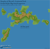
To recap, I have been developing the +World of Calidar on three different scales:
• World Map, 2 km/pixel
• Continental, 0.5 km/pixel
• Local, 0.125 km/pixel
The step down between each scale is a quadrupling of the previous one. So a single 100 x 100 pixel area of the world map would become a 400 x 400 pixel continental map, or a 1,600 x 1,600 pixel local map. It's important to understand that these scales all show the same area.
 |
| Kingdom of Meryath Scale Comparison |
The point to take away from this is perhaps rather obvious, but its implications are not. Clearly, higher resolutions show more detail. Moreover, erosion produces more realistic results at higher resolutions/larger scales. What's perhaps not so clear, but crucially important for cartography, is that the smaller scales are not meant to show things in great detail.
What this means is that even though the local scale map is much more detailed, it doesn't mean that it's better than the other maps. Although it could be used to make the other two maps more detailed, you have to ask yourself if that's necessary – or even desirable. Will it actually show more detail when reduced down so drastically? There's a real possibility that it will in fact do the opposite, obscuring the important details with a mess of barely visible tiny details.
This is the crux, which I forgot to state clearly in my article on scale: world maps need only show world level detail. Continental maps need only show continental detail. Local maps are where you can go all-out on fine detail, but even then, if you feel like you're crowding things in, perhaps it's time to move down to another, larger scale still.
Finally, here are the three images in the scale comparison all scaled to the same size. The local map has been shrunk down to less than a quarter its full size; the continental map is just a little smaller than full size; and the world map has been almost quadrupled from its native (rather tiny) size. Bearing in mind the purpose of each scale, it's interesting to compare the difference in detail shown on each map.
 |
 |
 |
| Local Scale | Continental Scale | World Map Scale |
No comments:
Post a Comment