 |
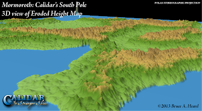
| Mormoroth, 3D view of Eroded Height Map, Polar Stereographic Projection |
 |
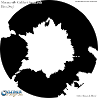
| First Draft, Polar Stereographic |
 |
| Second Draft, Polar Stereographic |
| First Draft, Equirectangular |
| Second Draft, Equirectangular |
Calidar was no different, and the polar regions caused so much trouble that at one point we considered simply having no land in these regions of the map at all. However, in the end we used map projections to solve the problem. The result is the design you see on the left.
The small strip below each Polar Stereographic map is the bottom strip of the Equirectangular world map, from 90ºS to 60ºS. In other words each of the above pairs of images displays the same area. Note how the first draft coastline design looks smooth on the Equirectangular map, and yet hideously spiked on the Polar Stereographic map.
What I did was to redraw the coastline on the Polar Stereographic map, resulting in the second draft image on the right. Then I reprojected the new design back to Equirectangular, and slotted it in to the world map – as you will see perhaps next week.
 |
| Mountain Design Polar Stereographic Projection (Cropped for erosion) |
With the projection issues sorted, I'm sure you all know by now what came next: mountain designs, followed by erosion. After Bruce gave me the okay on the new coastlines, I had to adapt the mountain design to it, then work on the height map.
The funny thing about Mormoroth is that since it lies at the south pole, most of the height map design will not be visible on any map – it will all be buried in a massive ice sheet, with only the highest mountains sticking out the top.
Undaunted by this, I went ahead and developed the area anyway. I have yet to work out how to implement the ice sheet itself... In the meantime, here are some views of the eroded height map – a peek beneath the ice sheet, if you like.
Join me again tomorrow as we journey north again to one of Calidar's undiscovered continents.


No comments:
Post a Comment