Welcome to week two of Map of the Day–the Calidar World Tour!
 |
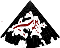
| Feorad Isle – Calidar's northernmost land, Lambert Conformal Conic Projection |
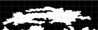 |
Feorad Isle, First Draft
Equirectangular Projection |
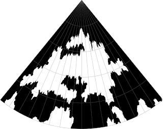 |
Feorad Isle, First Draft
Lambert Conformal Conic Projection |
We begin our world tour this week with a look at the top of the world–the north pole. There is no land at the pole itself, but there's an island close to it, which is known as Feorad Isle. It's likely a cold, mostly frozen land, the vast majority of which lies firmly within the Arctic Circle – which on Calidar lies at 66.5ºN.
Continuing last week's discussion of projection problems, the north and south polar areas of any world pose a particularly thorny problem for world builders working with a rectangular base map, such as the Equirectangular Projection. The problem is that areas north of 60ºN and south of 60ºS are stretched progressively more and more, until the single point of a pole is represented by the whole top or bottom edge of the map.
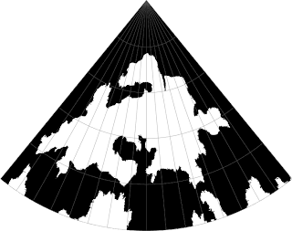 |
Feorad Isle, Second Draft
Lambert Conformal Conic Projection |
Draw landforms in the normal way, and they will invariably end up spiky and squashed-looking. You can see this in the first draft images on the left. The solution is to reproject the map to a more suitable projection, and design the area using that projection. Later, this can be projected back to Equirectangular and added back in to the base map – where of course it will now look stretched, but that's as it should be on that projection.
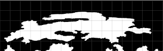 |
Feorad Isle, Second Draft
Equirectangular Projection |
The second draft black and white images show the fixed coastlines, first edited on a Lambert Conformal Conic Projection, then reprojected back to the base Equirectangular Projection.
It's important to consider projections when designing terrain, too, because otherwise the terrain will end up just as warped as the coastlines here were. This is why each of Calidar's continents has been designed using a projection chosen for that continent. The Great Caldera is circular, and away from the equator, so it uses the Stereographic Projection. Feorad Isle is close to the north pole, and so could use Polar Stereographic, but the other side of the pole is uninteresting, with no land, so instead I chose the Lambert Conformal Conic, whose shape is very efficient in this case.
 |
Mountain Design
Lambert Conformal Conic Projection |
Looking at these images again, I wonder if perhaps I have gone a little too far in reducing the spikiness of the terrain. What do you think? Please let me know in the comments.
After the coastlines have been fixed, it's time to build a height map, working from +Bruce Heard's mountain design. In this case, the design was squished by the projection change, so it required quite a bit of tweaking; working in an appropriate projection is important not just for coastlines, but also for terrain design. Even a long mountain range painted onto the Equirectangular projection maps above will be squashed down to a much shorter one when reprojected into Lambert Conformal Conic – or onto a globe.
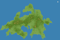 |
| Pre-erosion terrain design–satellite |
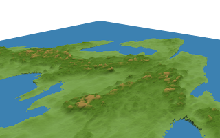 |
| Pre-erosion terrain design–3D view |
Once the base height map has been designed, it's time for simulated erosion. In the 3D views here you can see the map in its initial design stage, then in its finished stage. Note the very distinctive valleys carved into the land, and also how the blobby orange hills turn into sculpted peaks.
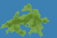 |
| Post-erosion terrain design–satellite |
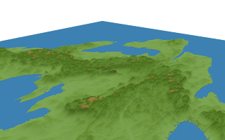 |
| Post-erosion terrain design–3D view |
As with the black and white coastline maps, the finished height maps are reprojected into Equirectangular form and added to the world map. In this way, the world map is slowly taking form. Once its complete, we'll be able to produce accurate maps of any section of the world in whatever projection is needed.
Next time on our world tour, we will journey southwards to one of Calidar's biggest continents of all.


No comments:
Post a Comment